Saturday, September 21, 2013
BUDDHA GAYA
BODI GAYA

Bodh Gaya is a religious site and place of pilgrimage associated with the Mahabodhi Temple Complex in Gaya district in the Indian state of Bihar. It is famous as the place where Gautama Buddha is said to have obtained Enlightenment (Bodhimandala).
For Buddhists, Bodh Gaya is the most important of the main four pilgrimage sites related to the life of Gautama Buddha, the other three being Kushinagar, Lumbini, andSarnath. In 2002, Mahabodhi Temple, located in Bodh Gaya, became a UNESCOWorld Heritage Site.[1]
HAKGALA
BOTANIC GARDENS HAKGALA 
Botanic Gardens at Hakgala were established in 1861 for the purpose of experimentation and promotion of Cinchona cultivation in Sri Lanka. The gardens lying in the hill country among Sri Lanka's tea plantations in the Nuwara Eliya district are located along the Badulla Road, 9.5 km South-east of Nuwara Eliya, the popular holiday resort.
Situated at an elevation of about 1745 m above mean sea level, Hakgala Botanic Gardens, about 28 hectares in extent, lie under the shadow of the Hakgala Rock (meaning “Elephant's jaw rock”). This massive rock towers to a height of about 2,200m behind the gardens and the surrounding forest reserve like a solitary giant.
The gardens take the shape of several terraces upon the lower slopes of the rock and face the Uva Valley, across which some magnificent views of the Madulsima and the Namunukula range of mountains are seen in the distant landscape. The climate of the Gardens is subtropical, cool, fresh and some what similar to an alpine atmosphere. The temperature ranges from 3°C to 15° C. While the lowest recorded was 3° C. The gardens receive rainfall from two monsoons. The South West from May to August and the North East from October to December, the annual average rainfall being about 2300 mm.
During the South west monsoon gusts of strong winds blow across the Gardens towards the Uva Valley, making weird sounds. During October to December. When thick mist envelope the gardens, heavy downpours of rain falls more frequent in the afternoon and evenings. The best time to see the gardens is probably from about mid March to the end of April, popularly known as the Nuwara Eliya seasons. The gardens put up their best display of temperate annual flowers, Roses and Orchids during this period.
The flora of the gardens is distinctly sub tropical and consists of representatives of the indigenous, montane flora intermingled with those introduced from other subtropical countries, systematically planted in various sections of the gardens.
| ||||||||||
HORTON PLAINS NATIONAL PARK
Horton Plains National Park is a protected area in the central highlands ofSri Lanka and is covered by montane grassland and cloud forest. This plateau at an altitude of 2,100–2,300 metres (6,900–7,500 ft) is rich inbiodiversity and many species found here are endemic to the region. This region was designated a national park in 1988. It is also a popular tourist destination and is situated 32 kilometres (20 mi) from Nuwara Eliya and 8 kilometres (5.0 mi) from Ohiya.
The Horton Plains are the headwaters of three major Sri Lankan rivers, theMahaweli, Kelani, and Walawe. In Sinhala the plains are known as Maha Eliya Plains. Stone tools dating back to Balangoda culture have been found here. The plains' vegetation is grasslands interspersed with montane forest, and includes many endemic woody plants. Large herds of Sri Lankan Sambar Deer feature as typical mammals, and the park is also an Important Bird Area with many species not only endemic to Sri Lanka but restricted to the Horton Plains. Forest dieback is one of the major threats to the park and some studies suggest that it is caused by a natural phenomenon. The sheer precipice of World's End and Baker's Falls are among the tourist attractions of the park.
Contents
[hide]Physical features
Horton Plains is located on the southern plateau of the central highlands of Sri Lanka.[2] The peaks of Kirigalpoththa (2,389 metres (7,838 ft)) andThotupola Kanda (2,357 metres (7,733 ft)), the second and the third highest of Sri Lanka, are situated to the west and north respectively. The park'selevation ranges from 2,100–2,300 metres (6,900–7,500 ft).[3] The rocks found in the park belong to the Archaean age and belong to the high series of the Precambrian era and are made up of Khondalites, Charnockites and granitic gneisses.[4][5] The soil type is of the red-yellow podsolic group and the surface layer is covered with decayed organic matter.[4]
The mean annual rainfall is greater than 2,000 millimetres (79 in). Frequent cloudy cover limits the amount of sunlight that is available to plants. The mean annual temperature is 13 °C (55 °F) but the temperature varies considerably during the course of a day, reaching as high as 27 °C (81 °F)during the day time, and dipping as low as 5 °C (41 °F) at night. During thesouthwest Monsoon season, the wind speed sometimes reaches gale force. Although some rain falls throughout the year, a dry season occurs from January–March. The ground frost is common in February. Mist can persist in the most of the day during the wet season.[6] Many pools and waterfalls can be seen in the park, and Horton Plains is considered the most important watershedin Sri Lanka.[2] The Horton Plains are the headwaters of important rivers such as the Mahaweli, Kelani, and Walawe.[2] The plains also feeds Belihul Oya, Agra Oya, Kiriketi Oya, Uma Oya, and Bogawantalawa Oya.[6] Due to its high elevation, fog and cloud deposit a considerable amount of moisture on the land. Slow moving streams, swamps, and waterfalls are the important wetland habitats of the park.

| Horton Plains National Park | |
|---|---|
IUCN category II (national park)
| |

World's End, a sheer precipice within the park
| |
SRI PADAYA
SRI PADAYA
 Mount Sinai was considered sacred at a much earlier date, Mt. Fuji surpasses it in beauty and height, and Mt. Kilash evokes a far greater sense of mystery. Nevertheless, no other mountain has been revered by so many people, from such a variety of religions, for so many centuries as Sri Pada has. In Sanskrit literature Sri Pada is called variously Mount Lanka, Ratnagiri (Mountain of Gems), Malayagiri or Mount Rohana. This last name, like its Arab and Persian equivalent, Al Rohoun, is derived from the name of the south western district of Sri Lanka where Sri Pada is situated. In several Tamil works it is known as Svargarohanam ( The Assent to Heaven) while the Portuguese called it Pico de Adam and the English Adam's Peak. In the Mahavamsa, the great chronicle of Sri Lanka written in the 5th century CE, it is called Samantakuta ( Samanta's Abode) while in modern Sinhalese it is often called Samanelakhanda (Saman's Mountain). Long before Buddhism came to Sri Lanka in about 246 BCE Sri Pada was revered as the abode the god called Samanta, or sometimes Saman or Sumana. This local mountain god was destined to go on to great things. The Theravada Buddhists of Sri Lanka later made Samanta the guardian of their land and their religion. With the rise of Mahayana Buddhism, a movement that began in south India from where it soon spread to the island, Samanta developed into Samantabhadra, one of the four principle bodhisattvas of Mahayana. Like his later manifestation, Samanta is usually depicted crowned and bejewelled, holding a lotus in his right hand and accompanied by a white elephant. At Weligama, an ancient port on Sri Lanka's south coast, there is a 12 ft high statue of Samantabhadra carved out of a huge moss-covered bolder. Pilgrims from India and northern Sri Lanka disembarking at Weligama were greeted by this bodhisattva's serene countenance as they set out on the long trek to Sri Pada. Today there is still a shrine to Samanta on the top of the mountain and another larger one near Ratnapura, some 19 kilometres from its foot. The name Sri Pada, while correctly referring only to the sacred (sri) footprint (pada) on its summit, is the most commonly used name for the mountain today. Mount Sinai was considered sacred at a much earlier date, Mt. Fuji surpasses it in beauty and height, and Mt. Kilash evokes a far greater sense of mystery. Nevertheless, no other mountain has been revered by so many people, from such a variety of religions, for so many centuries as Sri Pada has. In Sanskrit literature Sri Pada is called variously Mount Lanka, Ratnagiri (Mountain of Gems), Malayagiri or Mount Rohana. This last name, like its Arab and Persian equivalent, Al Rohoun, is derived from the name of the south western district of Sri Lanka where Sri Pada is situated. In several Tamil works it is known as Svargarohanam ( The Assent to Heaven) while the Portuguese called it Pico de Adam and the English Adam's Peak. In the Mahavamsa, the great chronicle of Sri Lanka written in the 5th century CE, it is called Samantakuta ( Samanta's Abode) while in modern Sinhalese it is often called Samanelakhanda (Saman's Mountain). Long before Buddhism came to Sri Lanka in about 246 BCE Sri Pada was revered as the abode the god called Samanta, or sometimes Saman or Sumana. This local mountain god was destined to go on to great things. The Theravada Buddhists of Sri Lanka later made Samanta the guardian of their land and their religion. With the rise of Mahayana Buddhism, a movement that began in south India from where it soon spread to the island, Samanta developed into Samantabhadra, one of the four principle bodhisattvas of Mahayana. Like his later manifestation, Samanta is usually depicted crowned and bejewelled, holding a lotus in his right hand and accompanied by a white elephant. At Weligama, an ancient port on Sri Lanka's south coast, there is a 12 ft high statue of Samantabhadra carved out of a huge moss-covered bolder. Pilgrims from India and northern Sri Lanka disembarking at Weligama were greeted by this bodhisattva's serene countenance as they set out on the long trek to Sri Pada. Today there is still a shrine to Samanta on the top of the mountain and another larger one near Ratnapura, some 19 kilometres from its foot. The name Sri Pada, while correctly referring only to the sacred (sri) footprint (pada) on its summit, is the most commonly used name for the mountain today. |
COMPUTER
What is a Computer?
A computer is a programmable machine. The two principal characteristics of a computer are: it responds to a specific set of instructions in a well-defined manner and it can execute a prerecorded list of instructions (a program).
Modern Computers Defined
Modern computers are electronic and digital. The actual machinery -- wires,transistors, and circuits -- is called hardware; the instructions and data are called software.
All general-purpose computers require the following hardware components:
In addition to these components, many others make it possible for the basic components to work together efficiently. For example, every computer requires a bus that transmits data from one part of the computer to another.
Computer Classification, By Size and Power
Computers can be generally classified by size and power as follows, though there is considerable overlap:
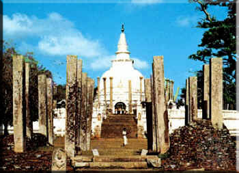
POLONNARUWA
Polonnaruwa 
The Mediaeval Capital of Sri Lanka
Polonnaruwa was a great city in Sri Lanka which came in to prominence during its' brief period of 2 Centuries of Sri Lankan history, being second only to the ancient city of Anuradhapura in ancient cultural heritage.
Polonnaruwa is 216 kMs from Colombo and 122 kMs from Kurunegala. Most common way to reach Polonnaruwa is to come to Habarana and then turning off along A11 Road [Maradankadawala-Tikkandimadu] and to proceed about 45 kMs to come to Polonnaruwa.
Polonnaruwa today is a showcase of the great ancient Sri Lankan architecture dating back to 12th Century AD ,which was interwoven with many Buddhist monasteries and monuments which were built by the King Parakramabahu I. Later King Nissankamalla (1187-1196 AD ) from Kalinga dynasty also had contributed to the development of many buildings and monuments at Polonnaruwa.
During the Anuradhapura period around 1st to 6th Century AD, , there has been agricultural developments with irrigation work and constructions such as Elahera canal,Minneriya tank, Kaudulla tank, Giritale tank etc. at Polonnaruwa area. The Anuradhapura kingdom's ruling King's army units were also stationed at Polonnaruwa . It had not been a major city at that time. King Aggabodhi IV ( 667-685 AD) was the First King who lived in Polonnaruwa and ruled the Anuradhapura Kingdom. In the earlier times this city was called as Pulatthinagara, after a famous sage, Pulasti which gives an indication of the Hindu influence existed.
King Parakramabahu I , was the greatest King who ruled Polonnaruwa during the Polonnaruwa era for 33 years from 1153-86 AD and it had been a prosperous time for the entire island nation. It was a time with numerous architectural activities which one can still see even in the present time. He developed the city with architects and technicians brought down from India and the influence of the Indian architecture can be seen from many well preserved sites existing today.Polonnaruwa Architecture, Art and Sculpture is well displayed at Gal Viharaya,Thuparamaya Image House and Lankatilaka Image House and many other sites scattered through out Polonnaruwa ancient city.
Due to invasions from the Cholas of South India, the Polonnaruwa kingdom was under the rule of Cholas for about 73 years. Polonnaruwa kingdom was abandoned by Sinhala kings in the latter part of the 12th century.
Famous places like Sigiriya,Medirigiriya, Somawathie, Dimbulagala and Buduruwayaya are not far away from Polonnaruwa so can be reached without much difficulty.
ANURADAPURA KINGDOM
Anuradhapura Kingdom
This is a world famous kingdom because of its well designed sanitary systems, gardens, temples and this kingdom was the capital of tha country for centuries.
Then his son King "Mutasiwa" becomes the ruler of the country and he rules the country for peaceful 60 years (367 BC - 307 BC ). Well known "Mahamewna Uyana" is an initiative of King "Mutasiwa". Next king was Mutasiwa's son "Dewanampiyatissa".
King Pandukabhaya - From 437 BC to 367 BC
King Pandukabhaya who was mentioned in Thammanna Kingdom is Unmada Chithra's son. He could take the throne from his uncles and got all the tribes and royalists under his throne. He built the first reservoir called "Abhayavapi" and shrines for "Chithraraja" and "Kalawela" who were his protectors. He was married to the princess "Swarnapali", his sister in low and ruled the country for great 70 years.Then his son King "Mutasiwa" becomes the ruler of the country and he rules the country for peaceful 60 years (367 BC - 307 BC ). Well known "Mahamewna Uyana" is an initiative of King "Mutasiwa". Next king was Mutasiwa's son "Dewanampiyatissa".
King Dewanampiyatissa - From 307 BC to 267 BC
This is the greatest time period in Sri Lanka's history because of the arrival of Buddhism. He had an early friendship with King "Ashoka" who ruled a province in India, and king Ashoka sent Buddhism to SriLanka as a gift. For this purpose he sent his son "Mahinda" thera and another five monks called "Ittiya" "Uththiya" "Sambala" "Baddhasala" and "Sumana" samanera.According to "Mahavansa" story, King "Dewanampiyatissa" was out for hunting and he has met Mahinda thera and others near "Mhintale". Then the king and his followers have been converted to Buddhism.
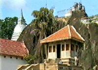
"Mihintale"
The location of Mahinda thera's arrival
After the conversion to Buddhism, lots of temples, dageba's were built. The first dageba of the country is "Thuparamaya" which was built by king Dewanampiyatissa enshrined Lord Buddha's collarbone. Another temple constructed by him is the ancient temple "Isuruminiya".
The next important incident is the arrival of "Sri Maha Bodhiya" which is a sapling from the original Bodhi tree under which Lord Buddha became enlightened.
It was brought by Theri "Sangamiththa", daughter of King Ashoka from India and it was planted in 288 BC, in Anuradhapura by king Dewanampiyatissa. It is the known oldest tree in the world.
Sub Kingdom - Magama
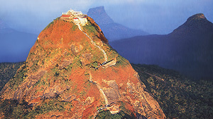
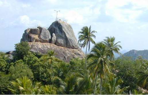
SIGIRIYA
The
ruins of the capital built by the parricidal King Kassapa I (477–95) lie on the
steep slopes and at the summit of a granite peak standing some 180m high (the
'Lion's Rock', which dominates the jungle from all sides). A series of
galleries and staircases emerging from the mouth of a gigantic lion constructed
of bricks and plaster provide access to the site.
 Ancient City of Sigiriya ©
Barbara Blanchard
Ancient City of Sigiriya ©
Barbara Blanchard
Sigiriya
is a unique witness to the civilization of Ceylon during the years of the reign
of Kassapa I. The site of the 'Lion Mountain' was visited from the 6th century
AD, by passionate admirers. The frescoes of Sigiriya inaugurated a pictorial
style which endured over many centuries. The poems inscribed on the rock by
certain of these admirers, and known as the 'Sigiri graffiti,' are among the
most ancient texts in the Sinhalese language, and thus show the considerable
influence exerted by the abandoned city of Kassapa I on both literature and
thought.
In
the heart of Ceylon, the extraordinary site of Sigiriya, a lofty rock of
reddish gneiss dominating, from a height of some 180m, the neighbouring
plateau, has been inhabited since the 3rd century BC, as attested by the
graffiti which proliferate in the grottoes and the shelters of the Buddhist
monks. The fame of the 'Lion Mountain' is, however, due to one single factor:
during a short period in the 5th century AD, a sovereign established his
capital there. King Kassapa I (477-95), son of Dhatusena, only came to power
after he had engineered the assassination of his father and had, briefly,
dispossessed his brother.
Justly
fearing the vengeance of the latter, Kassapa had a fortified palace built on
the rock of Sigiriya which was reputed to be impregnable. However, it was there
that he was defeated after a short but cruel battle in 495, following which he
cut his throat. After the death of Kassapa, Moggallana returned the site of
Sigiriya to the monks, thus condemning it to progressive abandonment. During
the eleven years that Kassapa resided in Sigiriya, he created a residence of
exceptional splendour and founded his capital there, impressive vestiges of
which are still extant.
Ancient Lanka has its
beginnings in the culture of stone, the stone Age. An ageless, timeless period,
the Stone Age In Sri Lanka stretched from 125,000 BC to 1000 BC. Encompassing
tens of thousands of years, the scales are so vast that we still cannot measure
it properly. It is like peering through a telescope, looking at a world so far
away that is visible only in fractions, a fleeting glimpse here and there. This
era is called "prehistory". The time before the dawn of history.It is during the
period that we find traces of early man. He appears to have lived almost
everywhere ; along the coast, on the plains and amongst the rolling grasslands
of the hill country. The richest evidence however survives in caves. It is only
then that the stone Age begins to take shape in our minds. At caverns like Fa
Hsien – lena, near Buthsinhala ( C 35,000 – 3400 BC ) Batadomba – lena in
Kuruwita ( C 29,000 – 9500 BC ) and Beli lena in Kitugala ( C 28,000 – 1500 BC
).The Balangoda Man
is a popular parlance, derived from his being responsible for the Mesolithic
"Balangoda Culture" first defined in sites near Balangoda. The bones
are robust, with thick skull-bones, prominent brow-ridges, depressed wide
noses, heavy jaws and short necks. The teeth are conspicuously large. These
traits have survived in varying degrees among the Veddas and certain Sinhalese
groups, thus pointing to Balangoda Man as a common ancestor.Sri Lanka has an
enthralling recorded history of civilisation. Its unique and proud historical
record of a great civilization spans over 25 chronicled centuries, and is
documented primarily in three books; the Mahavansa (Great Genealogy or
Dynasty), Dipavansa and Culavansa. Sri Lankan history is distinctive as it has
a historical record, which is ancient, continuous and trustworthy, and begins
with the occupation of the island by civilised men in 5th century, BC. The story continues under each
successive king for over 20 centuries. The Mahavamsa is primarily a dynamic and
religious historical record. In addition to this record, there are over 2500
inscriptions in Sri Lanka. The earliest inscriptions are contemporary with the
introduction of Buddhism in the 3rd century
BC. More than 1000 epigraphs, mostly inscribed on caves, belong to the third,
second and first centuries BC, exist in the dry zone as well as in the old
caves temples in Colombo, Kegalla, and Kandy.
vesak
|
|||||||||
|
|||||||||
|
|||||||||
|
|||||||||
|
|||||||||
|
|||||||||
|
|||||||||
|
|||||||||


Subscribe to:
Comments (Atom)